Printable map of Eurasia
Free PDFs, ready for A4 or Letter. Print in colour or black and white.
Printing a map of Eurasia
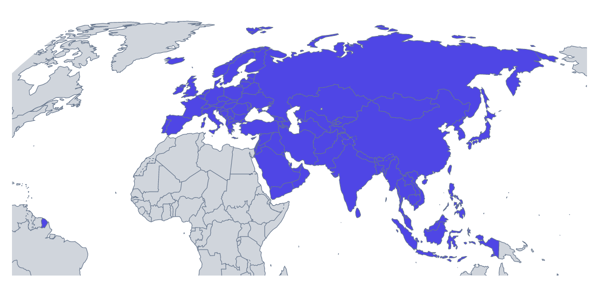
A printable map of Eurasia is used where a class needs both continents on one sheet: a lesson on trade routes, a project on the two together, a test that sets Europe against Asia. There are two versions, both PDFs for A4 or Letter, in colour or black and white, with no names printed: With country borders, which draws the 105 countries and territories, and a Blank outline.
One sheet, shared out
105 members is too many for one pupil to label in a lesson, so share them out. Give each pair five or six names from the list further down this page, ask them to find and write in those on their own copy, and put the finished sheets side by side. Together they cover the map, and the list checks it.
For a test, number eight members and ask for the names. For a project, a pupil can shade the countries on a route they have chosen and write the country names along it. Younger children can pick the three countries they know best, colour them and find the same three on the printable maps of Europe and Asia.
What to print
With country borders is the version for almost every task here, since the blank outline gives pupils no shapes to name. The smaller members are tiny on A4 or Letter, so for a display choose Customise before printing and download an A3 PDF. Black and white copies photocopy well; any members you shade first with the bar on the map print as greys. Neighbours can show the countries around the group in grey.
How to do it in MapMaker
- Choose With country borders for the 105 members, or Blank outline for the land alone.
- Select A4 or Letter, then Colour or Black and white.
- Print the PDF at 100% so the shapes keep their proportions.
- To shade the countries a lesson needs, pick a colour in the bar on the map, click them and choose Download your map.
- Choose Customise before printing for names, a title or an A3 sheet.
The 105 members on the map
A key for labelling the map by hand.
- Afghanistan
- Akrotiri Sovereign Base Area
- Åland
- Albania
- Andorra
- Armenia
- Australian Indian Ocean Territories
- Austria
- Azerbaijan
- Bahrain
- Bangladesh
- Belarus
- Belgium
- Bhutan
- Bosnia and Herzegovina
- Brunei
- Bulgaria
- Cambodia
- China
- Croatia
- Cyprus
- Czechia
- Denmark
- Dhekelia Cantonment
- Estonia
- Faroe Islands
- Finland
- France
- Georgia
- Germany
- Gibraltar
- Greece
- Guernsey
- Hong Kong
- Hungary
- Iceland
- India
- Indonesia
- Iran
- Iraq
- Ireland
- Isle of Man
- Israel
- Italy
- Japan
- Jersey
- Jordan
- Kazakhstan
- Kosovo
- Kuwait
- Kyrgyzstan
- Laos
- Latvia
- Lebanon
- Liechtenstein
- Lithuania
- Luxembourg
- Macau
- Malaysia
- Malta
- Moldova
- Monaco
- Mongolia
- Montenegro
- Myanmar
- Nepal
- Netherlands
- North Korea
- North Macedonia
- Northern Cyprus
- Norway
- Oman
- Pakistan
- Palestine
- Philippines
- Poland
- Portugal
- Qatar
- Romania
- Russia
- San Marino
- Saudi Arabia
- Serbia
- Singapore
- Slovakia
- Slovenia
- South Korea
- Spain
- Sri Lanka
- Sweden
- Switzerland
- Syria
- Taiwan
- Tajikistan
- Thailand
- Timor-Leste
- Turkey
- Turkmenistan
- Ukraine
- United Arab Emirates
- United Kingdom
- Uzbekistan
- Vatican City
- Vietnam
- Yemen
Facts about Eurasia
105 members are on the map.
Maps of places in Eurasia
Questions people ask
Which countries are on the printable map of Eurasia?
The 105 countries and territories on the map. The list further down this page names every one, which makes it the answer key for a labelling sheet or a quiz.
Can I print the map of Eurasia on A3?
Not from this page, which has A4 and Letter. Choose Customise before printing and download the same map as an A3 PDF, which gives the smaller members much more room on a wall display.
What is the difference between the blank outline and the version with country borders?
The blank outline shows the land of the map as one shape. The version with country borders adds the lines between the 105 members, so each has its own shape to label or colour. Neither has names printed.
Can I print it in black and white?
Yes, choose Black and white and the borders print as dark lines on white. Shade a few members first with the bar on the map and they come out as greys.