Printable map of the Mediterranean
Free PDFs, ready for A4 or Letter. Print in colour or black and white.
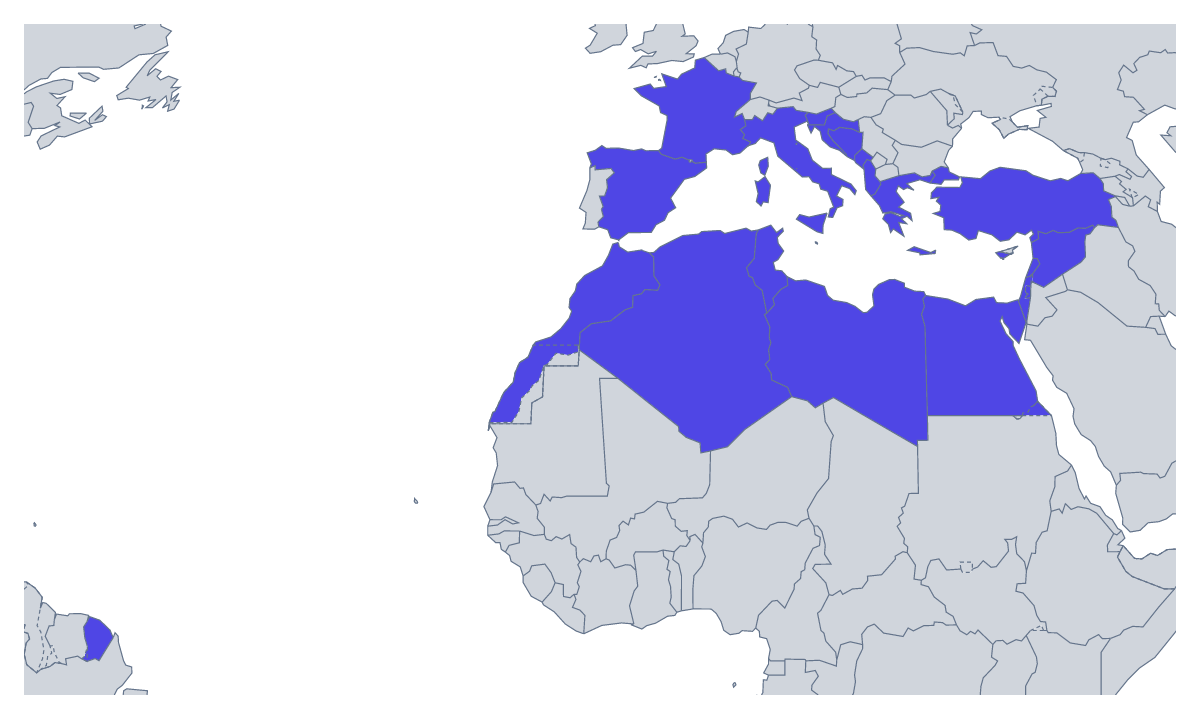
Printing a map of the Mediterranean
A teacher who prints the Mediterranean usually wants one sheet that will carry several lessons: countries, travel, a unit on the region. Pupils get a With country borders version, with every one of the 22 countries as its own shape, or a Blank outline of the region. Both are PDFs for A4 or Letter, in colour or black and white. No names are printed.
Starting small, then adding more
The 22 shapes will not all be learned in a lesson, so build the sheet up in stages. In the first lesson, number six on a copy and ask for the names of Spain, France, Italy, Greece, Turkey and Egypt. A week later, hand out a fresh copy with ten numbered. The list further down this page is the answer key at every stage.
Activities for different ages
Younger children can colour each country a different colour and add a compass rose in a corner. For an older class on travel, pupils plan a trip with four countries on the sheet, mark the stops in pencil and number them in order. A languages class can shade the countries where the language they study is used and add a key; a team of four can take a quarter of the map each and fit the pieces on a wall display.
Picking the version and the paper
Print With country borders for labelling, a quiz or colouring by a rule. Print the Blank outline when pupils will draw the borders themselves. Black and white suits a class set; colour suits a single sheet for the wall. If you want to shade some countries first, use the bar on the map and Download your map. The smallest countries are tiny at A4; for a display, Customise before printing gives an A3 sheet. Pupils who finish early can try the printable map of Europe alongside.
How to do it in MapMaker
- Choose A4 or Letter, then Black and white if you will photocopy a class set.
- Pick With country borders for the 22 countries, or Blank outline for the region alone.
- Print the PDF at 100% so the smallest countries stay visible.
- Colour the countries a lesson needs with the bar on the map, then choose Download your map.
- For names, a title or an A3 sheet, choose Customise before printing.
The 22 members on the map
A key for labelling the map by hand.
- Albania
- Algeria
- Bosnia and Herzegovina
- Croatia
- Cyprus
- Egypt
- France
- Greece
- Israel
- Italy
- Lebanon
- Libya
- Malta
- Monaco
- Montenegro
- Morocco
- Palestine
- Slovenia
- Spain
- Syria
- Tunisia
- Turkey
Facts about the Mediterranean
This map shows the countries with a coast on the Mediterranean Sea. 22 members are on the map.
Maps of places in the Mediterranean
Questions people ask
How many countries are on the printable map of the Mediterranean?
22 countries are on the map. The list further down this page names every one, so it works as an answer key whether pupils label a few of them or all of them.
Which version should I print for a labelling worksheet?
With country borders. Each of the 22 countries gets its own shape to name. The blank outline leaves the borders out, which suits pupils who draw them in from an atlas.
Are the names of the countries printed on the map?
No, so pupils can write them in. For a copy with names shown, choose Customise before printing, switch the names on in the editor and download a PDF from there.
Can I print the Mediterranean map in black and white?
Yes. Choose Black and white before you download and the PDF prints without colour, which photocopies cleanly for a class set and uses little ink.